
Q: We’ve covered the surveyor, lot sizing, TIF financing, phasing, stormwater, sewer and septic, and bonding. You said this final column would cover the one mistake that kills more subdivision projects than any other. What is it?
A: It’s assuming the FEMA flood map is accurate.
Almost every developer treats the Flood Insurance Rate Map as settled fact: land inside the mapped Special Flood Hazard Area is risky and expensive to build on, land outside it is clear. Neither assumption is safe, and the reason goes back further than most people realize.
Where these maps came from.
The National Flood Insurance Program was created by Congress in 1968, after the Mississippi River floods of 1927 and Hurricane Betsy in 1965 made clear the country needed some federal framework for flood risk. FEMA itself didn’t exist yet; it wasn’t created until 1979, when it absorbed the program. Many of the underlying flood studies were built using the topographic and rainfall data available at the time, in some cases old paper survey methods rather than a surveyor walking every parcel.
That produced errors in both directions. Some parcels on genuinely high ground got mapped into the high-risk zone because the map’s scale couldn’t capture small elevation differences. Others that do carry real flood risk were left out because the underlying data wasn’t good enough to catch them.
Has this been fixed? Not fully.
A 2017 Department of Homeland Security Inspector General investigation found that 58 percent of FEMA’s flood maps are considered inaccurate or out of date, and nearly two-thirds haven’t been updated in the last five years. Fewer than half of all mapped miles use modern LiDAR elevation data; the rest still rely on decades-old surveys with 20-foot contour intervals. Congress passed the Biggert-Waters Flood Insurance Reform Act in 2012 specifically to force more accurate, forward-looking maps, but the update process has consistently lagged the mandate.
National Geographic’s reporting on this puts it plainly: the government’s flood maps are “based on antiquated data and obsolete models.” The magazine’s reporting also found that this data gap hits hardest outside the coastal areas people usually associate with flood risk, particularly mountainous regions like Appalachia, where Hurricane Helene caused catastrophic flooding in communities the maps had never flagged.
Why this is a developer problem, not just a homeowner problem.
A homeowner deals with one lot. You’re platting dozens. An outdated map error doesn’t cost you one bad insurance quote, it can cost you an entire phase of buildable lots, or saddle every future homeowner in your subdivision with a mandatory flood insurance requirement on land that was never actually at risk. That liability follows the plat, not just the parcel.
This is where your choice of surveyor matters more than most developers realize. A surveyor who only establishes boundary lines and elevation benchmarks is doing half the job. What you actually need is someone competent in wetland identification and delineation, since the two problems travel together more often than not: land with an outdated or mismapped flood designation frequently also has unmapped or under-documented wetlands, which trigger their own separate federal review under Clean Water Act Section 404, administered by the Army Corps of Engineers, not FEMA. A surveyor who catches both issues on the same site visit saves you a second round of studies, and a second round of delay.
The fix: correct the map before you sell a single lot.
If your due diligence turns up land that’s genuinely on high ground but mapped into the flood zone, a licensed land surveyor can prepare an Elevation Certificate establishing the lot’s actual elevation against the Base Flood Elevation. If that elevation exists naturally, FEMA can issue a Letter of Map Amendment. If it was created with engineered fill as part of your site work, the correct document is a Letter of Map Revision Based on Fill instead. There’s no FEMA review fee for a LOMA; the fill-based version does carry one. Typical FEMA review runs 45 to 90 days once a complete application is submitted, occasionally longer for complex LOMR-F cases.
The developer’s advantage here is timing. Pursue this correction during platting, before lots are sold, and you’re fixing the problem once, for the whole subdivision. Leave it for individual homeowners to discover later, and each one has to run the same process alone, on their own dime, for a mistake your own site work already knew about.
What an incorrect map actually costs.
National average flood insurance premiums run roughly $900 to $1,100 a year, with wide swings by state, from around $425 in Alaska to nearly $1,900 in West Virginia. A mandatory insurance requirement attached to lots that don’t actually carry flood risk is a real, recurring cost that shows up in every buyer’s closing disclosure, and a sharp buyer’s agent will ask why it’s there. Correcting the map before you list removes that friction entirely, and it’s a selling point, not just a fix.
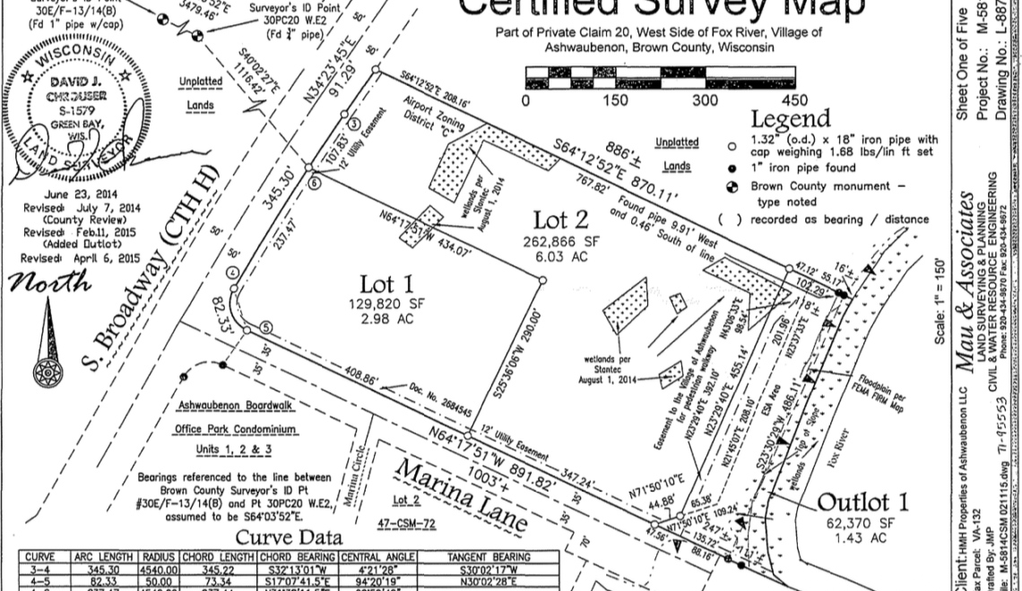
The image accompanying this column is a certified survey map prepared for one of my own projects along the Fox River, showing actual wetland delineations alongside the FEMA FIRM reference for that parcel. That’s what this looks like done right, the flood data and the wetland data documented together, on one map, before a single lot goes to market.
That closes the series. We started with the first call every landowner should make. We end here, because the map you’re trusting to tell you where the water goes may be older than the road you’re about to build.